Charleston County
County in de Verenigde Staten  | |||
|---|---|---|---|
 | |||
| Situering | |||
| Staat | South Carolina | ||
| Coördinaten | 32°49'12"NB, 79°54'0"WL | ||
| Algemeen | |||
| Oppervlakte | 3.518 km² | ||
| - land | 2.379 km² | ||
| - water | 1.139 km² | ||
| Inwoners (2000) | 309.969 (130 inw./km²) | ||
| Overig | |||
| Zetel | Charleston | ||
| FIPS-code | 45019 | ||
| Opgericht | 1769 | ||
| Website | Officiële website | ||
| Foto's | |||
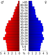 Bevolkingspiramide Charleston County | |||
| Statistieken volkstelling Charleston County | |||
| |||

Charleston County is een van de 46 county's in de Amerikaanse staat South Carolina.
De county heeft een landoppervlakte van 2.379 km² en telt 309.969 inwoners (volkstelling 2000). De hoofdplaats is Charleston.
Bevolkingsontwikkeling
| Jaar | Inwoners | % ± | |
|---|---|---|---|
| 1900 | 88.006 | — | |
| 1910 | 88.594 | 0,7% | |
| 1920 | 108.450 | 22,4% | |
| 1930 | 101.050 | −6,8% | |
| 1940 | 121.105 | 19,8% | |
| 1950 | 164.856 | 36,1% | |
| 1960 | 216.382 | 31,3% | |
| 1970 | 247.650 | 14,5% | |
| 1980 | 276.974 | 11,8% | |
| 1990 | 295.039 | 6,5% | |
| 2000 | 309.969 | 5,1% | |
| Bron: (en) Historical Decennial Census Population | |||

· Abbeville County · Aiken County · Allendale County · Anderson County · Bamberg County · Barnwell County · Beaufort County · Berkeley County · Calhoun County · Charleston County · Cherokee County · Chester County · Chesterfield County · Clarendon County · Colleton County · Darlington County · Dillon County · Dorchester County · Edgefield County · Fairfield County · Florence County · Georgetown County · Greenville County · Greenwood County · Hampton County · Horry County · Jasper County · Kershaw County · Lancaster County · Laurens County · Lee County · Lexington County · Marion County · Marlboro County · McCormick County · Newberry County · Oconee County · Orangeburg County · Pickens County · Richland County · Saluda County · Spartanburg County · Sumter County · Union County · Williamsburg County · York County


